

Salmon farms
21 October 2016
A new service harnesses three decades of satellite observations of coastal zones made available through a cloud-based system to provide a rich information source for fisheries, one of our fastest growing sources of food.
SAFI (Supporting our Aquaculture and Fisheries Industries) is a prototype information service supported by the EU’s Seventh Framework Programme. It uses Earth observation data to support the fishing industry.
Ensuring ease of use, SAFI accesses the powerful capabilities of the ESA-backed Coastal Thematic Exploitation Platform (C-TEP), a cloud-based ‘one-stop shop’ that gathers coastal-zone satellite data, processing algorithms and computing power.
The three-year SAFI project came to a close with a final workshop in Morocco at the end of September. Here, it was announced that SAFI will continue as a commercial undertaking.
“The UN Food and Agriculture Organisation recognises aquaculture as one of the fastest growing food-producing sectors, accounting for 90.4 million tonnes in 2012 – nearly 50% of the world’s food fish,” comments Antoine Mangin of Earth-observing company ACRI, overseeing SAFI.
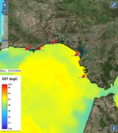
Sea-surface temperature Gulf of Cadiz
“There is an established need for simple user-oriented Earth observation tools to help guide the sector’s continued growth, and to set more accurate fishing quotas for coastal waters.
“Fish famers already pay very close attention to seasonal changes, to try and look for similarities between the current year and previous annual patterns. Our service – powered in turn by the C-TEP platform – supports such analysis, enabling the speedy processing of large amounts of data to make historical comparisons, statistical analysis and forecasting.
“Fish farming, for instance, needs to take place at specific temperature ranges for each fish species, among other environmental parameters such as turbidity.
“Using C-TEP, SAFI can work swiftly through tens of terabytes of data at a time to extract the temperature evolution over 20 years. Doing the same with additional variables like water transparency and wave height lets us quickly and easily pinpoint suitable farming location across the globe.
“We can also go on to calculate the environmental carrying capacity of the site, allowing users to forecast likely yields.”
“We can also go on to calculate the environmental carrying capacity of the site, allowing users to forecast likely yields.”
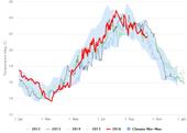
Gulf of Cadiz temperature
Regularly updated maps of shallow-water seabeds from Sentinel-2 images can also help to site mussel and other shellfish farms.
Along with three decades of archive satellite data, C-TEP gives access to the very latest imagery from the Copernicus Sentinel-2 and Sentinel-3 satellites, covering water colour, sea-surface temperature and height. Fresh data become accessible to SAFI on a near-real time basis for use in forecast models.
“We can give early warning of potential fish-killing phytoplankton blooms: green chlorophyll or red tide. In reaction, oxygen can be diffused into fish pens, although this is costly. Alternatively, fish can be harvested early.
“High waves can also be forecast, so that fish pens can be sunk deeper underwater. And, 30–50% of aquaculture costs come down to feeding. Fish eat less in lower temperatures, or when low-visibility conditions make them unhappy. SAFI allows these conditions to be forecast so operators can avoid wasting food.”
As training sessions during the Morocco workshop demonstrated, SAFI can be used almost anywhere, despite a lack of high-bandwidth connectivity. This is because C-TEP lets the data discovery, gathering and processing to be performed remotely, in the cloud.
C-TEP is one of six Thematic Exploitation Platforms developed by ESA to serve data user communities. As a new element of the ground segment delivering satellite results to users, these cloud-based platforms provide an online environment to access information, processing tools, computing resources and tools for community collaboration. The aim is to enable the easy extraction of valuable knowledge from vast quantities of environmental data now being produced by Europe's Copernicus programme and other Earth observation satellites.
ESAGuillermo Gonzalo Sánchez Achutegui
ayabaca@gmail.com
ayabaca@hotmail.com
ayabaca@yahoo.com
Inscríbete en el Foro del blog y participa : A Vuelo De Un Quinde - El Foro!
No hay comentarios:
Publicar un comentario