
http://esaintouch.net/
http://www.esa.int/spaceinimages/Images/2016/08/Ariane_5_liftoff_VA232
https://soundcloud.com/esa
http://www.esa.int/Highlights/Week_In_Images_22_26_August_2016
http://www.esa.int/Our_Activities/Telecommunications_Integrated_Applications/First_satellite-based_wildlife_monitoring_tool_for_airports
Stellar shrapnel

Details
- Title Stellar shrapnel
- Released 19/08/2016 12:41 pm
- Copyright ESA/Hubble & NASA, Y. Chu
- DescriptionSeveral thousand years ago, a star some 160 000 light-years away from us exploded, scattering stellar shrapnel across the sky. The aftermath of this energetic detonation is shown here in this striking image from the NASA/ESA Hubble Space Telescope’s Wide Field Camera 3.The exploding star was a white dwarf located in the Large Magellanic Cloud, one of our nearest neighbouring galaxies. Around 97% of stars within the Milky Way that are between a tenth and eight times the mass of the Sun are expected to end up as white dwarfs. These stars can face a number of different fates, one of which is to explode as supernovae, some of the brightest events ever observed in the Universe. If a white dwarf is part of a binary star system, it can siphon material from a close companion. After gobbling up more than it can handle — and swelling to approximately one and a half times the size of the Sun — the star becomes unstable and ignites as a Type Ia supernova.This was the case for the supernova remnant pictured here, which is known as DEM L71. It formed when a white dwarf reached the end of its life and ripped itself apart, ejecting a superheated cloud of debris in the process. Slamming into the surrounding interstellar gas, this stellar shrapnel gradually diffused into the separate fiery filaments of material seen scattered across this skyscape.
- Id 364183
TAGS
- Click on the tags to find the matching images.
- Activity Space Science
- Mission Hubble Space Telescope (HST)
The real thing
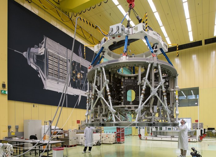
Details
- Title The real thing
- Released 24/08/2016 12:16 pm
- Copyright Airbus DS
- Description The European Service Module that will power NASA’s Orion spacecraft to the Moon and beyond is taking shape in the assembly hall at Airbus Defence and Space, Bremen, Germany. The spacecraft module will provide propulsion, electricity, water, oxygen and nitrogen and thermal control.Seen here is the primary structure that provides rigidity to the European Service Module much like the chassis of a car. It absorbs the vibrations and energy from launch while a secondary structure protects the module from micrometeoroids and space debris.Assembly of the thousands of components needed to build the advanced spacecraft started on 19 May with the arrival of the primary structure that was shipped from Turin, Italy, by Thales Alenia Space. In 2018 this structure will be an element of the European Service Module that will be launched into space, as part of the Orion spacecraft, on its first mission to fly more than 64 000 km beyond the Moon and back.In the background is a poster of ESA’s Automated Transfer Vehicle (ATV) that was also assembled in this hall in Bremen. Five ATVs flew to the International Space Station to deliver supplies and raise its orbit. Developing ATV provided the experience necessary to develop the European Service Module in Europe.
- Id 364275
TAGS
- Click on the tags to find the matching images.
- Activity Human Spaceflight
- Set Human spaceflight and operations image of the week
Ariane 5 liftoff VA232

Details
- Title Ariane 5 liftoff VA232
- Released 25/08/2016 12:16 am
- Copyright ESA
- Description On 24 August 2016, Ariane 5 flight VA232 lifted off from Europe’s Spaceport in French Guiana and delivered two satellites, Intelsat-33e and Intelsat-36, into their planned orbits.
- Id 364290
Proba-V views Great Salt Lake

Details
- Title Proba-V views Great Salt Lake
- Released 26/08/2016 9:14 am
- Copyright ESA/Belspo – produced by VITO
- Description Great Salt Lake, the largest salt lake in the western hemisphere, captured by ESA's Proba-V satellite last June.
Launched on 7 May 2013, Proba-V is a miniaturised ESA satellite – less than a cubic metre – tasked with a full-scale mission: to map land cover and vegetation growth across the entire planet every two days.
Its main camera’s continent-spanning 2250 km swath width collects light in the blue, red, near-infrared and mid-infrared wavebands at 300 m resolution and down to 100 m resolution in its central field of view.
VITO Remote Sensing in Belgium processes and then distributes Proba-V data to users worldwide. An online image gallery highlights some of the mission’s most striking images so far, including views of storms, fires and deforestation. - Id 364330
TAGS
- Click on the tags to find the matching images.
- Activity Observing the Earth , Space Engineering , Technology
- Mission Proba-V
Italy earthquake displacement

Details
- Title Italy earthquake displacement
- Released 26/08/2016 5:31 pm
- Copyright Contains modified Copernicus Sentinel data (2016)/ESA/ CNR-IREA
- DescriptionCombining two Sentinel-1 radar scans from 20 August (Sentinel-1B) and 26 August 2016 (Sentinel-1A), this interferogram shows changes that occurred during the 24 August earthquake that struck central Italy.The seven interferometric ‘fringes’ correspond to about 20 cm of surface deformation in the radar sensor line of sight. Each fringe (which is associated to a colour cycle) corresponds to approximately 2.8 cm of displacement.Although Sentinel-1 has a swath width of 250 km over land surfaces, its pass over Italy on 26 August did not cover the entire area affected. Another acquisition planned for 27 August will cover the entire earthquake zone.
- Id 364362
TAGS
- Click on the tags to find the matching images.
- Activity Observing the Earth
- Mission Sentinel-1
- System Copernicus
- Location Italy
- Keywords Earthquakes
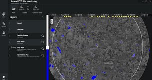
First satellite-based wildlife monitoring tool for airports
29 August 2016
Wildlife habitats close to airports pose a serious risk to safety at takeoff and landing. Thanks to ESA, a new service lets airports use satellites to identify and manage these areas.
Developed by Ascend XYZ in Denmark with ESA’s help, the service uses free images and data from Earth observation satellites combined with smart software.
Several airports in Denmark have tested the Ascend software and found it far easier to use than existing complicated standalone systems.
Focusing on risk sites has increased their efficiency and reduced costs and enabled them to comply with the legal requirement to monitor within a 13 km radius.
Detecting water via satellite
"Using Earth observation data is more efficient than on-ground monitoring, requiring fewer man-hours and lowering demands on resources which cuts costs while increasing flight safety,” commented Peter Hemmingsen, CEO at Ascend.
“This is especially valuable to smaller airports with fewer resources to meet the same safety standards as large airports.
“Free data from the latest Copernicus Sentinel satellites make this an affordable solution for airports.”
Two airports have already signed up to the service.
Several international airports from Germany, England and North America also plan to adopt it.

Registering a lake in Ascend
In the software, users can identify risk sites such as lakes, golf courses, rubbish dumps, seasonal crops and other areas that attract wildlife – birds in particular. This provides a full overview of all the sites around the airport.
Satellite pictures are updated weekly, so changes in the water levels of lakes and flooded fields can be monitored and the site visited. All actions can be documented in the software.
The software can also generate alerts such as reminders to visit a site, monitor it via the satellite images, or contact the authorities if changes occur.
Sites can be marked on maps and field personnel can visit specific areas guided by satellite navigation data from Ascend.

Field personnel locate sites through satnav
Reports and images generated in Ascend can also be used for auditing purposes and to create a wildlife management report. Without the Ascend solution, airports require a costly team of specialists to do this.
The cloud- and browser-based management system allows the information to be shared online between airport operators, ground staff, civil aviation authorities, the wildlife management team and others involved in airport operations.
Early next year, Ascend intends to extend their service to identify objects that exceed height restrictions in restricted areas.
“ESA’s ARTES Applications programme merges big space data with smart ideas,” noted Arnaud Runge, Ascend Project Manager at the Agency.
“Ascend is an excellent example of how space can increase efficiency, cuts costs, solve problems and, in this case, make our skies safer.”
Guillermo Gonzalo Sánchez Achutegui
ayabaca@gmail.com
ayabaca@hotmail.com
ayabaca@yahoo.com
Inscríbete en el Foro del blog y participa : A Vuelo De Un Quinde - El Foro!
No hay comentarios:
Publicar un comentario