
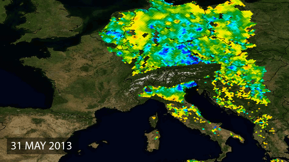
Soil moisture from SMOS
7 June 2013
As parts of central Europe are battling with the most extensive floods in centuries, forecasters are hoping that ESA’s SMOS satellite will help to improve the accuracy of flood prediction in the future.
As its name suggests, the Soil Moisture and Ocean Salinity (SMOS) mission monitors the amount of water held in the surface layers of the soil and the concentration of salt in the top layer of seawater.
This information is helping scientists understand more about how water is cycled between the oceans, atmosphere and land – Earth’s water cycle. It is also helping to improve weather forecasts.
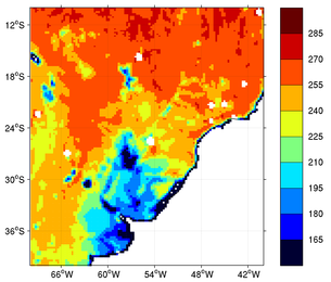
The massive flooding that central Europe is currently suffering was brought about by a wet spring and sudden heavy rains.
SMOS in orbit
SMOS carries a novel microwave sensor to capture images of ‘brightness temperature’ to derive information on soil moisture.
Prior to the torrential rains, SMOS showed that soils in Germany were showing record levels of moisture – in fact, the highest ever observed.
The animation above shows the wet soils in blues and the dryer soils in yellows.
ESA’s SMOS mission scientist, Matthias Drusch, explains, “Data from SMOS can be used to monitor the saturation of the soil.
Flood mapping through the International Charter
“At the end of May we see that the soil was almost fully saturated, with record values for moisture. More rain meant that it immediately ran off as the surplus water could not soak into the soil, and this resulted in these terrible floods.
“Numerical Weather Predication centres are currently assessing the possibility of using SMOS data to improve weather and flood forecasts, so hopefully we will be better placed to predict these events more accurately in the future. ”
Satellite missions such as Germany’s TerraSAR-X and RapidEye are providing imagery to aid the relief effort through the International Charter Space and Major Disasters.
WATER MISSION EXTENDS ITS TALENTS TO CARBON
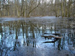
Flooded forest, Czech Republic
ESA’s SMOS satellite is not only proving its worth by mapping soil
moisture and ocean salinity, this multifaceted satellite has now shown
that it can ‘see’ through vegetation to monitor wetlands for a better
understanding of Earth’s carbon cycle.
It is widely appreciated that wetlands are important resources of freshwater and are rich in biodiversity.
However, it is less well known that wetlands also emit large quantities of methane – in fact, they contribute more methane to the atmosphere than any other natural source. Wetlands can also be both sources and sinks of carbon.
Although there is less methane in the atmosphere than carbon dioxide, methane is a much more powerful greenhouse gas. It is estimated that atmospheric methane was responsible for about 20% of the rise in global temperatures last century.
Methane emissions are mostly a result of human activity, but wetlands are thought to be responsible for about 20–40% of global emissions.
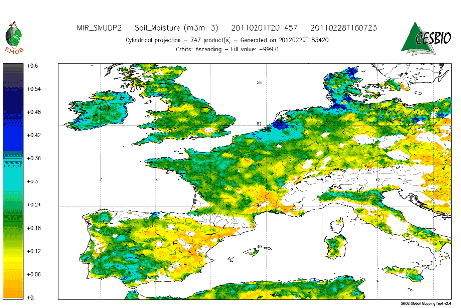
SMOS measurements
ESA’s SMOS water mission carries a novel microwave sensor to capture images of ‘brightness temperature’ to derive information on soil moisture and ocean salinity. This information is improving our understanding of water cycle.
However, SMOS is showing itself to be a very versatile tool and extending its usefulness to other areas of Earth science.
Surpassing expectations, SMOS is also being used to monitor thin Arctic sea ice, map freezing soil, determine wind speeds under hurricanes and monitor ocean eddies. Extending the value of SMOS even further, studies have shown that monitoring wetlands could be added to the mission’s repertoire.
Because SMOS measures emitted radiation at a rather long wavelength of 21 cm, vegetation and the atmosphere have little affect on the observations. This means it is possible to look at how wetlands change over time.
Such information is extremely valuable for our understanding of the role that wetlands play in the carbon cycle and how they contribute to atmospheric methane.

Inundation from multiple satellites
Catherine Prigent from the Paris Observatory explains, “SMOS offers the opportunity to implement fast and easy single satellite algorithms for monitoring wetland areas.
“This complements current methods of analysis that require a lot of work to blend the different products.”
A future SMOS product could be interesting for the GlobWetland II project. This programme, which is funded through ESA’s Earth Observation Data User Element, is helping to establish the Global Wetlands Observing System.
Here, high-resolution optical data such as that from the Sentinel-2 mission, could be combined with the coarse-resolution SMOS observations to make optimal use of available remotely-sensed information.
SMOS in orbit
Integrating SMOS observations into global carbon models is another novel application that was presented during the SMOS land application workshop held in February in Italy.
SMOS: The global success story continues
22 February 2013
ESA’s water mission is shedding new light on the meandering Gulf Stream, just one of the SMOS satellite’s numerous achievements.
Launched in 2009, ESA’s Soil Moisture and Ocean Salinity satellite has been helping us to understand the water cycle.
Over the past three years it has been providing more accurate information on global soil moisture and ocean salinity.
Launched in 2009, ESA’s Soil Moisture and Ocean Salinity satellite has been helping us to understand the water cycle.
Over the past three years it has been providing more accurate information on global soil moisture and ocean salinity.
Europe soil moisture decrease
Originating in the Caribbean and flowing towards the North Atlantic, the current plays an important role in the transfer of heat and salt, influencing the climate of North America’s east coast and Europe’s west coast.
Salinity observations from SMOS show that warm, salty water being carried north by the Gulf Stream meets the colder, less-salty water transported southward along North America’s east coast by the Labrador Current, mixing the water masses off Cape Hatteras.
SMOS can distinguish between and follow the resulting eddies that are ‘pinched off’ from the current and form little parcels of warm and salty water in the Labrador Current, and the colder, fresher water in the Gulf Stream.
SMOS in orbit
These and other scientific achievements from three years of the SMOS mission were presented at a conference held today at ESA’s European Space Astronomy Centre in Villanueva de la Cañada, near Madrid, Spain. SMOS was realised with special contributions from France and Spain.
“SMOS is the second Earth Explorer we have placed in orbit – and is delivering important new information on global soil moisture and ocean salinity for a broad range of applications,” noted Volker Liebig, ESA Director of Earth Observation Programmes.
The mission’s Lead Investigators, Yann Kerr and Jordi Font, are the focal point of the scientific research of the mission and lead discussions on soil moisture and ocean salinity findings.

Hurricane Sandy from SMOS
Surpassing expectations, SMOS data are being used to monitor Arctic sea-ice extent and thickness, providing daily coverage of the Arctic Ocean.
In addition, the satellite can determine wind speeds under hurricanes – such as last year’s Hurricane Sandy that devastated parts of the US east coast – by measuring the microwave radiation emitted by rough seas.
Today’s workshop included a welcome by the head of ESA’s European Space Astronomy Centre in Spain, Álvaro Giménez, and a speech on the future of space technology in Spain by Luis Valero, Spain’s General Secretary for Industry and SMES.
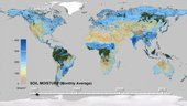
OVER 30 YEARS OF GLOBAL SOIL MOISTURE OBSERVATIONS FOR CLIMATE
The datasets are now available to the science community for feedback analyses and climate model validation.
The amount of water held in global soils makes up only about 0.001% of the total water found on Earth.
It is crucial for plant growth, but is also linked to our weather and climate. This is because soil moisture is a key variable controlling the exchange of water and energy between the land and the atmosphere: dry soil emits little or no moisture to the atmosphere.
The water cycle
The relationship between soil moisture and the climate system is not yet fully understood, and global long-term soil moisture observations have so far not been available. That means the evaluation of climate models with regard to the drying and wetting trends and associated feedbacks with temperature is still difficult in many regions worldwide.
In 2009, ESA launched a dedicated satellite mission, SMOS, that provides high quality and direct measurements of soil surface soil moisture. While the key applications for SMOS data are weather forecasting, hydrology and water management, the mission also provides data in near-real time for operational applications.

SMOS
These activities were initiated within the Water Cycle Multi-mission Observation Strategy project, led by ITC (The Netherlands), inside ESA’s Support To Science Element programme. The activities are now being continued and refined in the context of the Climate Change Initiative.
ESA is announcing the release of the first soil moisture climate data record spanning the period 1978 to 2010.
The 32 years of data allow for a robust calculation of the climatology, which in turn can be used to calculate anomalies. For example, areas of drying are evident, such as in the central US in 2005, Brazil and East Africa in the summer of 2007, southern China in the winter of 2009–10 and in 2010 in Russia.
Flooding is also evident, such as in Afghanistan in 1992, East Africa in 1998–99, Morocco in 2008 and the 2010–11 Queensland floods in Australia.
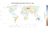
Soil moisture June–August 2010
The other dataset was generated by the Vrije University of Amsterdam in collaboration with NASA, based on passive microwave observations from the Nimbus-7, DMSP, TRMM and Aqua missions.
The harmonisation of these datasets aimed to take advantage of both types of microwave techniques but proved difficult owing to sensor degradation, drifts in calibration and algorithmic changes in the processing systems.
Challenges also included guaranteeing consistency between the soil moisture data retrieved from the different active and passive microwave instruments.
Since this is the first release of such a product, an active cooperation of the remote sensing and climate modelling communities is required to validate the satellite data jointly to understand modelling results better.
Scientists worldwide can now download, use, validate the dataset and provide feedback to the scientific team for further improvements. Users can register to access the data at www.esa-soilmoisture-cci.org.

SMOS soil moisture index
In addition, NASA’s SMAP mission is planned for launch in November 2014.
ESA
Guillermo Gonzalo Sánchez Achutegui
ayabaca@gmail.com
ayabaca@hotmail.com
ayabaca@yahoo.com
Inscríbete en el Foro del blog y participa : A Vuelo De Un Quinde - El Foro!
No hay comentarios:
Publicar un comentario