
 GCS
GCSGalileo's Ground Control Segment (GCS) in the Fucino Control Centre in Italy oversees Galileo navigation services and satellite payload operations.
 (98.32 kB)
 (1.35 MB)
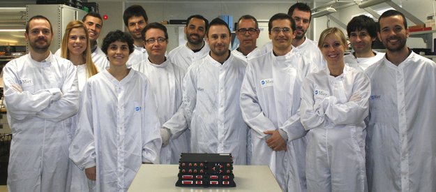
On a humid afternoon in French Guiana, a small team of Spanish engineers
watched as the second pair of Galileo satellites was launched, and the
outcome of many years of effort ascended to the heavens.
With a quartet of Galileo satellites in space and the second two undergoing in-orbit testing, Europe’s own satnav programme is nearing the time when the first navigation fixes can be tried out.
It has taken the combined knowledge, capabilities and skill of companies both large and small from across our continent to reach this point.
This team, from Spain’s Mier Comunicaciones company, had contributed two key items to the twin satellites, launched on 12 October 2012: a new search and rescue transponder to pick up emergency distress calls from the ground or sea, and the Mission Receiver vital to maintaining Galileo’s positioning accuracy by picking up terrestrial correction messages.

 (2.07 MB)
“It was quite a striking moment to see the launch,” recalls Pedro Mier, CEO of Mier Comunicaciones.
“We have been involved with Galileo since the very first pilot studies,
but for these first four satellites in the constellation we held direct
responsibility for key pieces of equipment.
“To begin with, this second pair of satellites was the first to carry
search and rescue transponders as part of the international
Cospas–Sarsat system, picking up signals from emergency beacons on boats
or aircraft in distress and relaying them to regional emergency
centres.”
 (69.46 kB)
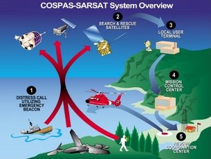
Cospas-Sarsat has been active for more than three decades, but Galileo’s
transponders are a new departure for the system, operating in medium
orbits for the first time, as opposed to low or geostationary orbits.
They also have the first return link for Cospas–Sarsat, able to reply to
stricken vessels that their SOS has been received and help is on the
way.
“We both designed and produced the transponder. Significantly for our
company, this was the first time we delivered a complete satellite
transponder,” adds Mr Mier.
 (1.52 MB)
“The design had to include very sharp signal filters and efficient
amplifiers within the transponder to pick up faint VHF signals within a
wide satellite footprint, and all within a compact size and mass.
“It also had to be compatible with both Galileo satellite designs – the
initial as well as follow-on Full Operational Capability satellites.
“But the single greatest challenge was undoubtedly the extremely
challenging schedule: in order to fly we had to design, qualify and
produce the transponder in less than 14 months. It was very demanding
but we did it!”
Satellite navigation
Why Galileo?
Galileo will ensure Europe's independence in a sector that has become critical for its economy and the well-being of its citizens.
It is worth noting that it is not
only the United States (GPS) who has constructed its own GNSS (global
navigation satellite system). Other countries are also developing their own GNSS and Europe should not be left out in the cold. A
scenario where European business is unable to benefit from the multiple
economic, environmental, innovative, research and employment opportunities offered by Europe having its very own satellite navigation system is not desirable.
GPS (US), GLONASS (Russia) and the other regional systems developed by Japan and China are military systems under
military control – indeed they provide a civil service but that civil
service could be either switched off or made less precise when desired
e.g. in case of conflict.
We have become so dependent on services provided by satellite navigation in our daily lives that
should a service be reduced or switched off, the potential disruption
to business, banking, transport, aviation, communication etc. to name
but a few, would be very costly (e.g. in terms of revenues for business,
road safety etc.).
With Galileo, Europe is
also able to exploit the opportunities provided by satellite navigation
to a much greater extent than otherwise possible. Galileo will
help Europe maintain and develop its know-how in the space, receivers
and applications sectors, securing economic revenues and jobs.
Independent surveys and market forecasting indicate that this and the
externalities in terms of public utility (new applications making
transport more effective, better road management, traffic less
polluting, rescue operations more effective etc.) are worth up to 90 billion euros over the first twenty years.
The combination of Galileo and
GPS signals in dual receivers will open the door to new applications
that require a higher level of precision than currently available with
GPS alone. This includes for example applications to guide the blind, to
increase the success rate of rescue operations in the mountains, to
monitor the whereabouts of people suffering from Alzheimers' Disease,
etc.
In addition, Galileo will improve
the overall availability and coverage of GNSS signals. For example, the
higher number of satellites will improve the availability of the
signals in high rise cities where buildings can obstruct signals from
satellites that are low on the horizon. Thanks to the location and
inclination of the satellites, Galileo will achieve a better coverage at
high latitudes than other systems, which is particularly interesting
for northern Europe, an area currently not very well covered by GPS.
Galileo in short: precision, availability, coverage
- Precision: In a combined GPS-Galileo use (compared to GPS by itself) the higher number of satellites available to the user will offer higher precision. From most locations, six to eight Galileo satellites will be visible which, in combination with GPS signals, will allow positions to be determined up to within a few centimetres.
- Availability: The high number of satellites will also improve the availability of the signals in high-rise cities, where buildings can obstruct signals from satellites that are low on the horizon.
- Coverage: Galileo will also provide a better coverage at high latitudes than GPS, thanks to the location and inclination of the satellites. This will be particularly interesting for Northern Europe.
Concerning the performances of
combined open GPS and Galileo receivers, please click here to view the
joint statement of the US and EU Working Group :
Brochures
Brochures


Satellite navigation
Programme
On this page:
Who is involved?
The definition phase and the
development and In-Orbit Validation phase of the Galileo programme were
carried out by the European Space Agency (ESA) and co-funded by ESA and
the European Union.
The Full Operational Capability
phase of the Galileo programme is fully funded by the European Union and
managed by the European Commission. The Commission and ESA have signed a
delegation agreement by which ESA acts as design and procurement agent
on behalf of the Commission.
Phases of the programme
The Galileo programme has been structured according to two main phases:
1. In-Orbit Validation (IOV) phase:
The IOV phase consists of
qualifying the system through tests and the operation of two
experimental satellites and a reduced constellation of four operational
satellites and their related ground infrastructure.
The two experimental satellites
were launched in respectively December 2005 and April 2008. Their
purpose was and is to characterise the Medium-Earth Orbit (MEO)
environment (radiations, magnetic field etc.) and to test in such
environment the performance of critical payload technology (atomic
clocks and radiation hardened digital technology). They also provide an
early experimental signal-in-space allowing to secure the frequency
spectrum required for Galileo in accordance with WRC RNSS allocations.
The two first two operational satellites were launched on the 21 October 2011, followed by the launch of the third and fourth operational satellites on the 12 October 2012.
2. Full Operational Capability (FOC) phase:
The FOC phase consists of the
deployment of the remaining ground and space infrastructure. It includes
an intermediate initial operational capability phase with 18 satellites
in operation (the four IOV satellites plus 14 others). The full system
will consist of 30 satellites, control centers located in Europe and a
network of sensor stations and uplink stations installed around the
globe.
Galileo services definition
The Galileo mission and services
have been elaborated during the initial definition phase in consultation
with user communities and the Member States.
The services that are planned to be provided by Galileo are the following:
- Open Service: basic signal provided free-of-charge;
- Safety-of-Life Service: Enhanced signal including an integrity function that will warn the user within a few seconds in case of a malfunction. This service will be offered to the safety-critical transport community e.g. aviation. It will be certified according to the applicable standards e.g. those of the International Civil Aviation Organisation (ICAO) and to the Open Sky regulations;
- Commercial Service: combination of two encrypted signals for higher data throughput rate and higher accuracy authenticated data;
- Public Regulated Service: two encrypted signals with controlled access for specific users like governmental bodies;
- Search And Rescue Service: Galileo will contribute to the international COSPAS-SARSAT cooperative system for humanitarian search and rescue activities. Each satellite will be equipped with a transponder transferring the distress signal from the user to the Rescue Coordination Centre and informing him that his situation has been detected.
Galileo Architecture
The Galileo full infrastructure will be composed of:
- A constellation of 30 satellites in Medium-Earth Orbit (MEO). Each satellite will contain a navigation payload and a search and rescue transponder;
- 30-40 sensor stations;
- 3 control centres;
- 9 Mission Uplink stations;
- 5 telemetry, tracking and command (TT&C) stations.

Galileo Procurement
Early January 2010, the European
Commission announced the award of three of the six contracts for the
procurement of Galileo's initial operational capability.
- The contract for the system support services was awarded to Thales Alenia Space and covers the industrial services needed to support the European Space Agency for the integration and the validation of the Galileo system.
- The contract for a first order of 14 satellites was awarded to OHB System AG. The first satellite is expected to be delivered in July 2012 and the last one in March 2014. The remaining 12 to 14 satellites needed to reach the Full Operational Capability will be procured in subsequent work orders from either OHB or EADS Astrium GmbH under the framework contract signed with both manufacturers.
- The contract for the launch services was awarded to Arianespace and covers the launch of five Soyuz launchers, each carrying two satellites. The first launch took place the 21 October 2011 and the second launch is planned for the 12 October 2012, both from Kourou, in French Guiana.
The contracts were signed on 26
January between the European Space Agency, acting on behalf of the
European Commission, and the companies involved.
On 25th October 2010, the
contract for the operations was signed with SpaceOpal GmbH (an
Italian-German joint venture) and the European Space Agency on behalf of
the European Commission.
The final two procurement
contracts for the ground mission infrastructure and the ground control
infrastructure were awarded in June 2011.
Satellite navigation
Galileo/EGNOS: range of potential applications
EGNOS is already operational.
A clear timeline has been set for the implementation of Galileo.
Opportunities for the development of applications based on Europe's very
own global navigation satellite systems are many – especially given the
systems' capabilities in terms of positioning, navigation and timing.
Market opportunities exist in
a wide range of domains (in all modes of transport, precision
agriculture and personal mobility) in a global market for GNSS products
and services of more than 100 billion Euros per year, to double by 2030.
To foster development, the European Commission issued, on 14 June 2010, an Action Plan on GNSS applications  encompassing 24 measures focusing on the 2010-2013 period. This plan aims at increasing the EU share of the satellite navigation (GNSS) global market (currently 20%, but with the objective to reach 33%, like in other high-tech sectors) and at improving the EU's independency in this field (currently 6-7% of EU GDP relies on the American GPS).
Today EGNOS provides the user with improved accuracy thanks to the corrections it brings to the GPS signal.
Moreover, in urban areas where acquiring the signal from the satellites
becomes difficult and entails a loss of accuracy, EGNOS can still
provide its corrections through the EGNOS Data Access Server (EDAS)
provided over the Internet.
As far as Galileo is concerned, the improved characteristics of its signals in terms of power, band used make it more efficient in challenging environments
than a traditional GPS receiver. But combined with GPS, associated
benefits are brought in terms of both accuracy and availability.
Domains of application
The European Commission is committed to 6 priority domains identified in the impact assessment accompanying its Action Plan on GNSS Applications:
- applications for individual handsets and mobile phones (LBS),
- road transport;
- aviation;
- maritime transport;
- precision agriculture and environment protection;
- civil protection and surveillance.
The Public Regulated Services is a specific domain restricted to authorized users by governments.
Fostering GNSS pervasiveness
As well as the above-mentioned
application domains on which the European Commission acts to develop
related EGNOS and Galileo-based applications, cross-cutting measures are
being implemented to foster GNSS pervasiveness in general and to
enhance innovation.
For instance, the European Commission funds R&D activities through the Seventh
Framework Programme of the European Union for research, technological
development and demonstration activities (2007-2013), in particular
related to the reduction of EGNOS/Galileo receiver costs and supports
the establishment of an international prize to promote innovative
EGNOS/Galileo-enabled applications.
GNSS awareness raising will be
promoted through an international Galileo Application forum, the
establishment of a virtual information centre and with a dedicated
action towards SME through instruments of the Entrepreneurship and
Innovation Programme (EIP).
Synergies will also be sought with other programmes such as those run by the European Investment Bank or the Technology Transfer Programme from ESA, or with other initiatives such as GMES, GEOSS and telecommunication programmes to enhance combined services.
Reference documents, links and contact
Guillermo Gonzalo Sánchez Achutegui
ayabaca@gmail.com
ayabaca@hotmail.com
ayabaca@yahoo.com
Inscríbete en el Foro del blog y participa : A Vuelo De Un Quinde - El Foro!
No hay comentarios:
Publicar un comentario